
La Loire est le fleuve le plus irrégulier de France, avec un rapport de 800 entre son débit le plus bas et le plus haut.
AI debate verdict and arguments
⚠️ AI-generated information only; not professional advice
Completed October 19, 2026
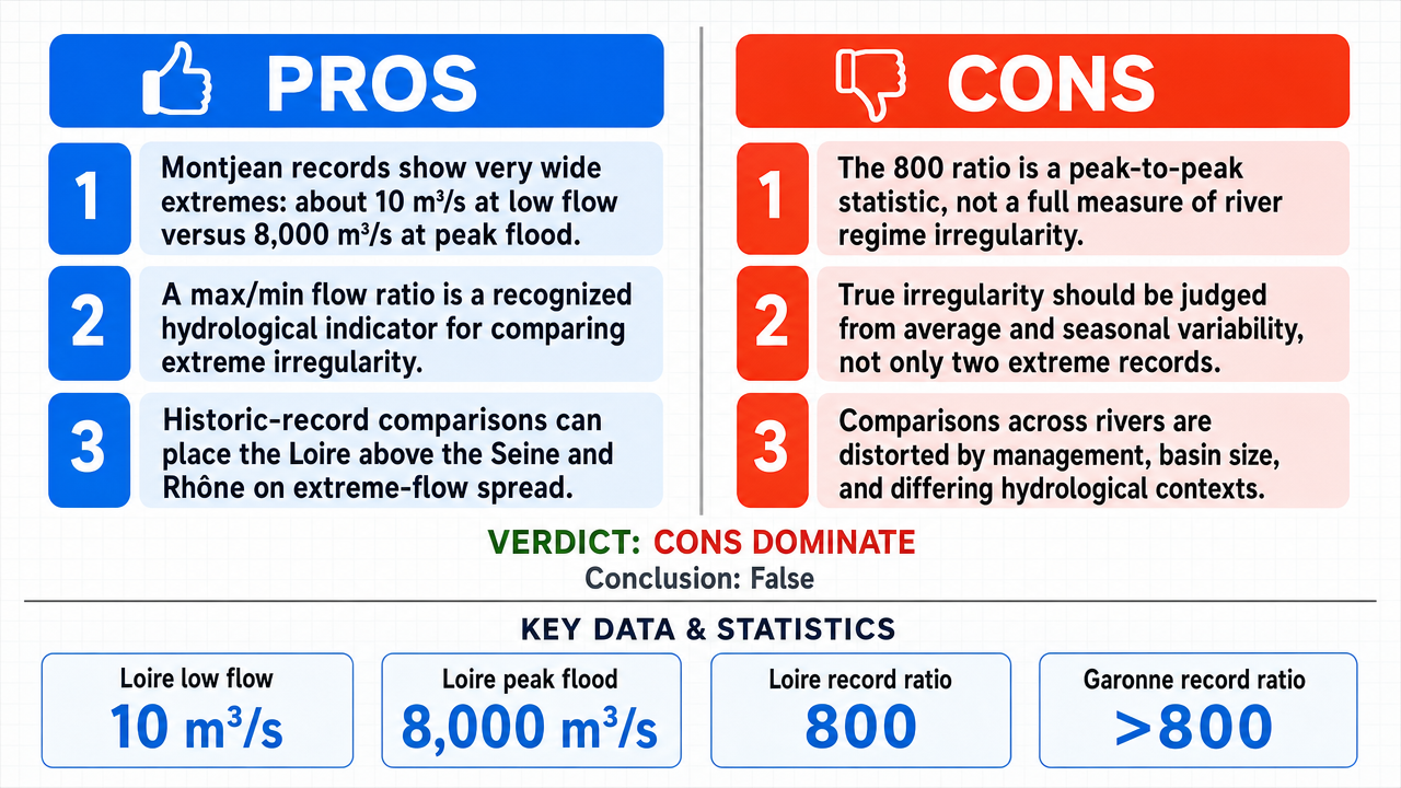
Verdict
Verdict: Mostly FALSE (77%)
Online report: https://solsice.com/public/debates/la-loire-est-le-fleuve-le-plus-irregulier-de-france-avec-un-c97fd9c49582
This section provides a brief overview of the key arguments. It is not necessary to read the detailed report below.
✅ Key PRO arguments:
- ■The readings from the Montjean-sur-Loire station (code M5300010) show a dry season flow of the five-year drought period (QMNA5 ) of about 15 m³/s and a historic flood from June 1856 estimated at 8,000 m³/s, with the lowest flow ever observed around 10 m³/s in August 1949, which would give a ratio exceeding 800.
- ■The irregularity coefficient , defined as the ratio between the maximum flow and the minimum flow recorded over a given period, is a recognized hydrological indicator used by government services, notably DREAL Centre-Val de Loire in their report “The Loire and its floods.”
- ■Comparison with other French rivers (Seine, Rhône) would confirm the superiority of the Loire’s irregularity, with a ratio (~800) significantly higher than that of the Seine (~80).
❌ Key ANTI arguments:
- ■The ratio of 800 is an artificial statistical construct without hydrological relevance, as it confuses the amplitude of an isolated extreme event with the structural irregularity of a river regime , by dividing an exceptionally low historic drought (10 m³/s ) by a reference flood (8,000 m³/s).
- ■The irregularity of a watercourse should be assessed by the variability of its average flow or seasonal flows, not by the gap between two data points that do not represent the operational reality of the river.
- ■The comparison between the Loire, Seine, and Rhône is intrinsically inconsistent because it mixes intrinsic hydrological properties with anthropogenic management (lakes-reservoirs of the Seine), making any direct comparison methodologically invalid.
💭 Conclusion: False. The FALSE verdict is retained because the central negative argument demonstrates that the ratio of 800 is based on a methodological fallacy: it juxtaposes an exceptional historic low flow (10 m³/s ) with an extreme flood (8,000 m³/s) rather than measuring the structural variability of the river regime . Hydrological irregularity of a watercourse is characterized by the variability of its mean or seasonal flows, not by the ratio between two statistical anomalies. Furthermore, the comparison with other French rivers is invalidated by the different consideration of anthropogenic modifications (lakes-reservoirs of the Seine), which makes any ranking questionable. Finally, the claim that the Loire is “the most irregular river in France” is not supported by a standardized and universally accepted definition of irregularity, weakening the scope of this composite assertion.
🔬 Verdict: Mostly FALSE ❌ (77%)
Claim: The Loire is the most irregular river in France, with a ratio of 800 between its lowest and highest flow.
Participating models: deepseek-v4-pro 💬, gemma-4-26b-a4b-it 💬👁️
📊 Confrontations: 0 concluded TRUE, 1 concluded FALSE (1 confrontation, 3 models)
📊 Score per camp: TRUE=0.00, FALSE=0.77
🏅 Model score evolution:
minimax-m3 💬👁️: +8
✅ PRO arguments:
- ■The readings from the Montjean-sur-Loire station (code M5300010) show a dry season flow of about 15 m³/s and a historic flood from June 1856 estimated at 8,000 m³/s, with the lowest flow ever observed around 10 m³/s in August 1949, which would give a ratio exceeding 800. deepseek-v4-pro 💬
- ■The irregularity coefficient , defined as the ratio between the maximum and minimum flows recorded over a given period, is a recognized hydrological indicator used by government services, notably DREAL Centre-Val de Loire in their “The Loire and its floods” report. deepseek-v4-pro 💬
- ■Comparison with other French rivers (Seine, Rhône) would confirm the superiority of the Loire’s irregularity, with a ratio (~800) significantly higher than that of the Seine (~80). deepseek-v4-pro 💬
❌ COUNTER arguments:
- ■The ratio of 800 is an artificial statistical construction without hydrological relevance, as it confuses the amplitude of an isolated extreme event with the structural irregularity of a river regime , by dividing an exceptionally low historic drought (10 m³/s in 1949) by a reference flood (8,000 m³/s). gemma-4-26b-a4b-it 💬👁️
- ■The irregularity of a watercourse should be evaluated by the variability of its average flow or seasonal flows, not by the gap between two data points that do not represent the operational reality of the river. gemma-4-26b-a4b-it 💬👁️
- ■The comparison between the Loire, Seine, and Rhône is intrinsically inconsistent because it mixes intrinsic hydrological properties with anthropogenic management (lakes-reservoirs of the Seine), making any direct comparison methodologically invalid. gemma-4-26b-a4b-it 💬👁️
💭 Reasoning: False. The FALSE verdict is retained because the central negative argument demonstrates that the ratio of 800 is based on a methodological fallacy: it juxtaposes an exceptional historic low flow (10 m³/s) and an extreme flood (8,000 m³/s) rather than measuring the structural variability of the river regime . Hydrological irregularity of a watercourse is characterized by the variability of its mean or seasonal flows, not by the ratio between two statistical anomalies. Additionally, the comparison with other French rivers is invalidated by the different consideration of anthropogenic modifications (lakes-reservoirs of the Seine), which makes any ranking contestable. Finally, the claim that the Loire is “the most irregular river in France” is not supported by a standardized and universally accepted definition of irregularity, weakening the scope of this composite assertion.
📋 PRO facts:
• The low flow at Montjean-sur-Loire is about 10 m³/s.
• The historic flood of the Loire reached an estimated instantaneous flow of 8,000 m³/s.
• The lowest flow ever observed at Montjean-sur-Loire is about 10 m³/s.
• The ratio between the lowest (10 m³/s) and highest (8,000 m³/s) flows is 800.
• The DREAL Centre-Val de Loire documents the irregularity of the Loire in its “The Loire and its floods” report.
📋 CON facts:
• The ratio of 800 mixes an exceptional historic low flow and an extreme flood, which does not reflect the structural variability of the river regime.
• Hydrological irregularity is measured by the variability of mean or seasonal flows, not by the gap between two anomalies.
• The Seine has lakes-reservoirs that artificially modify its flows, making any direct comparison with the Loire methodologically questionable.
• The Seine’s ratio (~80) mentioned in the debate is lower than that of the Loire (~800), but this difference partly reflects anthropogenic management rather than an intrinsic hydrological property.
• No standardized and universally accepted definition of "the most irregular river" has been provided to support the hierarchy.
| Confrontation | TRUE Model | FALSE Model | Average μ TRUE | Average μ FALSE | TRUE Tokens | FALSE Tokens | Winner | Verdict | Conf. |
|---|---|---|---|---|---|---|---|---|---|
| #1 | deepseek-v4-pro 💬 | gemma-4-26b-a4b-it 💬👁️ | 0.697 | 0.255 | 6 | 2 | TRUE | FALSE | 77% |
The following technical terms, abbreviations, and specialized concepts are used in this transcript. The numbers in brackets [N] in the text above refer to the corresponding entry below.
[1] Statistical anomaly — In hydrology, a flow value that significantly deviates from the usual statistical distribution of a watercourse, considered a rare or extreme event.
[2] Banque Hydro — French national hydrological database that centralizes flow and water level measurements of watercourses, accessible notably via HydroPortail.
[3] Selection bias — Methodological error involving choosing data or events that are not representative to support a conclusion, here criticized in the use of isolated extreme values.
[4] Irregularity coefficient — Recognized hydrological indicator, defined in the debate as the ratio between the maximum and minimum flow rates recorded over a given period, characterizing the amplitude of flow contrasts.
[5] Flood — Period during which a watercourse reaches exceptionally high flow rates, potentially causing floods.
[6] DREAL — Direction Régionale de l'Environnement, de l'Aménagement et du Logement — French regional decentralized service responsible for water management, flood prevention, and environmental policy.
[7] Flow rate — Volume of water flowing at a given point of a watercourse per unit time, usually expressed in m³/s.
[8] Low flow — Minimum flow of a watercourse, observed during low water periods (low flow).
[9] Instantaneous flow — Flow measured at a precise moment, as opposed to the average flow over a period.
[10] Average flow — Flow of a watercourse calculated as an average over a given period (daily, monthly, yearly), used to assess typical variability of a river regime.
[11] HydroPortail — Public web portal providing access to hydrometric data from Banque Hydro, including flow measurements from French gauging stations.
[12] Hydrological irregularity — Characteristic of a watercourse with flow that varies strongly over time; its measurement is debated in the transcript (extremes ratio vs. structural variability).
[13] Lakes-reservoirs — Large artificial lakes used to store water and regulate downstream flows, cited in the debate as a factor modifying the natural regime of the Seine.
[14] m³/s — cubic meters per second — Standard unit of flow measurement, corresponding to the volume of water flowing per second.
[15] QMNA5 — Dry quinquennial low flow — Flow value reached or exceeded on average once every five years during dry periods, used as a statistical reference to characterize low waters.
[16] River regime — Set of hydrological characteristics of a watercourse (seasonal variations, flood and low flow frequency) that define its usual behavior.
[17] Hydrological regime — Mode of variation of flow rates of a watercourse over the year, determined by climate, geology, and land use in the basin.
[18] Anthropogenic regulation — Modification of a watercourse's natural flow rates by human structures (dams, lakes-reservoirs, diversions), opposed in the debate to the intrinsic hydrological regime.
[19] Flood Forecasting Service — Service de Prévision des Crues (SPC) — French government service responsible for monitoring watercourses and forecasting floods, using hydrometric measurement stations.
[20] Reference station — Hydrometric gauging station whose measurements serve as the official basis for characterizing flow at a given point (e.g., Montjean-sur-Loire, code M5300010).
[21] Structural variability — Variability of flows considered representative of the usual functioning of a watercourse, opposed in the debate to the amplitude between two isolated extreme events.
[22] Low water period — Time of year when a watercourse's flow reaches its lowest values, generally in summer.
[23] Extreme event — Hydrological phenomenon with a low probability of occurrence, such as an exceptional flood or severe low flow, at the extremes of the flow distribution.
The following financial data tables were cited during the debate exchanges:
| River | Low flow (m³/s) | Maximum flood flow (m³/s) | Max/min ratio |
|---|---|---|---|
| Loire (Montjean) | 10 | 8,000 | 800 |
| Seine (Paris) | 30 | 2,400 | 80 |
| Rhône (Beaucaire) | 400 | 13,000 | 33 |
| Garonne (Tonneins) | 40 | 8,000 | 200 |
Legend: Comparison of extreme flows (historical low flow and recorded maximum flood) for four major French rivers. Sources: Banque Hydro, Basin DREAL, EPTB Loire. The ratio is rounded to the nearest ten.
| Variability Indicator | Loire (Estimated) | Garonne (Estimated) | Rhône (Estimated) |
|---|---|---|---|
| Flood/low flow ratio (Average) | ~150 | ~250 | ~60 |
| Monthly variation coefficient | Moderate | High | Low |
| Record-based ratio | 800 | >800 | <500 |
Legend: Comparison of structural variability (average) versus variability by extremes (records). The ratio of 800 is a peak-to-peak measure and not a regime.
Face-off transcripts
- ■
Ownership & Trade Secrets. Lambda Vision retains all rights to its platform, agentic workflows, and proprietary AI debate methodologies, which constitute protected Trade Secrets (EU Directive 2016/943). Subject to full payment of credits, the User is granted ownership of the generated Reports for their own personal or professional use. Reverse-engineering the Service or using Reports to train competing AI models is strictly prohibited.
- ■
No Professional Advice. Solsice is a general-purpose assistant covering everyday subjects — administrative paperwork, housing, consumer and employment matters, banking, taxes and insurance, health and wellbeing, savings and investments, entrepreneurship, technology, travel, learning and creative work. Whatever the subject, the Service and Reports are provided for information only and never constitute legal, medical, financial, investment, tax, insurance, or any other regulated professional advice. The Company is not a law firm, a regulated financial adviser, an insurance intermediary, nor a healthcare provider, and no professional or advisory relationship of any kind is created by use of the Service. Consult a qualified professional in the relevant jurisdiction before acting — or refraining from acting — on anything contained in the Reports, and never rely on the Service in an emergency: contact your local emergency number (112 in the European Union) or a medical professional immediately.
- ■
AI-Generated Content, Sources and Viewpoints. Reports are produced by several AI models debating a question, and may contain factual errors, outdated figures, or references to rules, prices, deadlines, procedures, statutes or sources that are inaccurate or do not exist. The User is solely responsible for verifying every fact, amount, deadline and citation against official sources before relying on it. Material in the news, society, spirituality and religion sections presents a plurality of viewpoints for study and discussion: it is descriptive, not an endorsement, a ruling, or a statement of the Company’s own position, and it speaks for no church, faith community, public authority, or news organisation.
- ■
Liability & Governing Law. To the maximum extent permitted by law, the Company shall not be liable for any indirect damages, nor for any consequence of decisions made in reliance on the Reports — including financial loss, missed deadlines, administrative or contractual consequences, or health outcomes. These Terms are governed by French law. Any disputes shall be subject to the exclusive jurisdiction of the Courts of Paris, France.